It’s a hurricane! No, it’s a tropical storm. No, it’s... a hurricane again? The storm system known as Hermine can’t seem to make up its mind. But either way, it could prove extremely dangerous to the mid-Atlantic and East Coast in the days ahead.
Hurricane or not, Hermine is still a potential threat to the East Coast

Photo by NOAA via Getty Images
Back on Thursday, Hermine became a full-blown Category 1 hurricane in the Gulf of Mexico, with 80 mph winds. It was the first hurricane in 11 years to make landfall in Florida, leaving one dead and 250,000 people without power.
As the hours passed and Hermine marched north through Florida, Georgia, and the Carolinas, it got downgraded to a “tropical storm.” It was still powerful, featuring heavy rains and gusts, but it was no longer quite a hurricane.
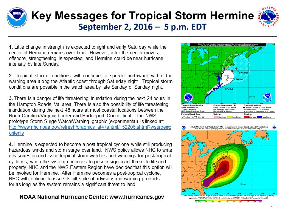
But we’re not done: The National Hurricane Center now says Hermine could strengthen again to “near hurricane intensity” as it moves into the warm Atlantic Ocean over the weekend. The newly revitalized storm could cause damage for hundreds of miles around, including the risk of “life-threatening inundation” at most coastal regions between North Carolina and Connecticut. This is very serious stuff — people in the warning areas below need to prepare:

(National Hurricane Center)
So what’s the difference between a “hurricane” and a “tropical storm,” anyway? Wind speed, mostly — although both can wreak plenty of havoc. In any case, here’s a simple guide to the key terms used to describe these sorts of storms, using Hermine as an example:
1) Tropical disturbance: A hurricane in the Atlantic Ocean typically begins life as a lowly tropical disturbance — defined as organized thunderstorm activity that stretches at least 100 miles across and maintains its identity for more than 24 hours. During the summer, these disturbances often start as storms moving westward from Africa.
If meteorologists think a tropical disturbance may develop further, they’ll designate it as an investigative area or invest. Hermine started out in mid-August as “Invest 99L,” with forecasters keeping close watch as it headed for the Gulf of Mexico.
2) Tropical depression or cyclone: Under the right conditions, a tropical disturbance can develop further and start to spin around a low-pressure center. Once that happens, it’s classified as a “tropical cyclone” or “tropical depression”:

(BBC)
For a tropical depression to form, the water has to be warm enough to fuel the system (80°F or higher), and there needs to be enough moisture in the lower and middle part of the atmosphere. Local winds also have to be just right and allow the depression to spin — too much wind shear can tear an aspiring tropical cyclone apart.
3) Tropical storm: As the pressure in the center of the system drops, air rushes in, creating strong winds. If the system strengthens and wind speeds rise past 39 mph, the system is dubbed a tropical storm and is given a name. That’s what happened to Hermine on August 31 as it entered the warm waters of the Gulf of Mexico and intensified.
The US National Hurricane Center makes the call for when a tropical depression becomes a tropical storm. They’ll rely on data from islands and buoys as well as from reconnaissance aircrafts that fly into the storms to measure wind speed.
4) Hurricane: Tropical storms can intensify quickly if they pass over a region of especially warm water and don’t face much wind shear. As that happens, the pressure in the center drops even further and the winds really pick up. The system gets rounder and often forms a clearly defined “eye.” Here’s Hermine on September 1:
#Hermine even looks like a hurricane now. There’s the beginnings of an eye. pic.twitter.com/wawBmSgV8O
— Sean Breslin (@Sean_Breslin) September 1, 2016
When the winds reach sustained speeds of 74 mph or more, the storm system is classified as an hurricane. Hurricanes are categorized according to the Saffir-Simpson Scale based on their wind speed and propensity for damage. Hermine was a Category 1:

(NOAA)
5) Back to tropical storm: Hurricanes can also weaken, however, as they move over land (or cooler water) and no longer have warm moist air to fuel them. Once wind speeds drop below 75 miles per hour, the hurricane gets downgraded to a tropical storm — and, later on, a “post-tropical cyclone” as it degrades further.
Hermine was downgraded to a tropical storm not long after it hit Florida early Friday. But, as Hermine moves back over the Atlantic Ocean next week and hits record-warm ocean temperatures there, it may pick up enough fuel to become a hurricane again, or at least close to it:
Sunday, #Hermine will begin transition into a fully-tropical hurricane, will be massive off Mid-Atl coast. 965 mb pic.twitter.com/PVApJZquct
— Ryan Maue (@RyanMaue) September 2, 2016
Weather forecast models currently expect Hermine to linger and seethe off the coast of New Jersey for several days, leading to storm surges and flooding throughout the area. Even without making landfall, Hermine can cause plenty of havoc.
NWS forecast for Atlantic City, NJ -- FOUR DAYS of tropical storm conditions, with #Hermine just chilling offshore pic.twitter.com/zbbUYgjSYk
— Sam Lillo (@splillo) September 2, 2016
It’s worth emphasizing that Hermine can be dangerous even if it doesn’t become a hurricane — even tropical or post-tropical storms can do a great deal of damage through torrential rain, dangerous surf, beach erosion, high winds, and flooding. In 2012, “superstorm” Sandy was technically no longer a hurricane when it hit the East Coast, but it still proved devastating to the New York and New Jersey coasts.
That’s why the National Weather Service is urging caution for anyone in Hermine’s path, whether it turns out to be a hurricane or tropical storm:

(National Hurricane Center)
How to follow Hermine:
- Do check out the National Hurricane Center’s webpage for Hermine updates. Anyone planning to be along the East Coast this Labor Day should really be checking frequently. There's also a Twitter account.
- The Capital Weather Gang is tracking the storm both on its excellent site and on Twitter. Both are definitely worth following for frequent updates.


